
Category:Maps of Labrador
Wikimedia category | |||||
| Upload media | |||||
| Instance of | |||||
|---|---|---|---|---|---|
| Category combines topics | |||||
| Labrador | |||||
region in the province of Newfoundland and Labrador, Canada    | |||||
| Instance of | |||||
| Part of | |||||
| Named after |
| ||||
| Location | |||||
| Inception |
| ||||
| Population |
| ||||
| Area |
| ||||
| Replaces |
| ||||
| Different from | |||||
 | |||||
Subcategories
This category has only the following subcategory.
Media in category "Maps of Labrador"
The following 45 files are in this category, out of 45 total.
-
 James Cook York harbour labrador.jpg 1,534 × 1,062; 279 KB
-
 A chart of the Gulf Stream inverted right to left (8475486331).jpg 800 × 610; 112 KB
-
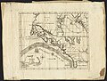
 HIND(1863) LABRADOR-EXP. p544 MAP OF THE PENINSULA OF LABRADOR.jpg 3,325 × 2,561; 3.75 MB
-

-

-
 Admiralty Chart No 1136 Belle Isle Strait Red Bay, Published 1838.jpg 6,537 × 7,436; 6.07 MB
-
 Admiralty Chart No 133 St Lewis Sound and Inlet, Published 1863.jpg 8,586 × 6,630; 6.75 MB
-
 Admiralty Chart No 1422 Labrador, Published 1871 02.jpg 11,066 × 8,375; 14.16 MB
-
 Admiralty Chart No 1422 Labrador, Published 1871.jpg 16,433 × 12,093; 49.82 MB
-
 Admiralty Chart No 223 Plans of Anchorages on N.E. Coast of Labrador, Published 1867.jpg 8,598 × 11,940; 10.69 MB
-
 Admiralty Chart No 264 Passages into Sandwich Bay, Published 1821.jpg 13,747 × 11,914; 12.63 MB
-
 Admiralty Chart No 324 Hamilton Inlet to Belle Isle, Published 1947, Large Corrections 1960.jpg 16,322 × 11,078; 14.55 MB
-
 Admiralty Chart No 375 Labrador Hamilton Inlet (Ivucktoke Inlet), Published 1864.jpg 11,978 × 8,219; 5.47 MB
-

-
 CapeChidleyAreaMap.png 539 × 752; 19 KB
-
 Churchill river newfoundland and churchill falls.PNG 514 × 423; 18 KB
-
 Company Publicity brochure Map 20 miles to 1 inch of Labrador, 1934.jpg 467 × 643; 332 KB
-

-

-

-

-
 Goose Bay Location.png 843 × 735; 604 KB
-
 Hunt River and Florence Lake greenstone belts.png 323 × 483; 12 KB
-
 Innus.png 450 × 483; 19 KB
-
 Labrador boundary dispute.png 577 × 711; 40 KB
-
 Labrador City.png 523 × 774; 30 KB
-
 Labrador from the Most Recent Surveys (1910).jpg 2,400 × 2,478; 818 KB
-
 Labrador fullmap.gif 408 × 500; 13 KB
-
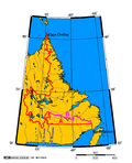
 Labrador Region Map with Towns and Highway.svg 1,274 × 1,382; 580 KB
-
 Labrador Riding Map 2013.png 974 × 910; 15 KB
-
 Labrador Road-paved&unpaved.jpg 219 × 196; 26 KB
-
 Labrador, riding.png 559 × 450; 15 KB
-
 Labrador-Region.PNG 2,000 × 1,697; 576 KB
-
 Lake Melville-Hamilton Inlet-Groswater Bay.png 1,752 × 904; 1.53 MB
-
 Largest Panethnic Groups in Atlantic Canada, 2021 Census.jpg 1,584 × 1,942; 255 KB
-

-
 Map of Musgrave Land.png 1,507 × 771; 708 KB
-
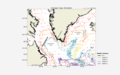 Map of the Labrador & Irminger seas. With depth contours and current data.png 1,728 × 1,080; 514 KB
-
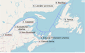
 Nunatsiavut & Nunavik.png 690 × 570; 15 KB
-
 Nunatsiavut in Newfoundland and Labrador.svg 1,512 × 2,162; 1.32 MB
-
 Nunatsiavut location map.svg 1,114 × 942; 326 KB
-
 Nunatsiavut.png 280 × 230; 53 KB
-
 Quebec RedBay ibilbidea.png 1,167 × 727; 333 KB
-
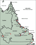
 The Labrador coast. A journal of two summer cruises to that region (1891) (20586277298).jpg 3,131 × 3,508; 1.78 MB
-
 The Labrador coast. A journal of two summer cruises to that region (1891) (20764845032).jpg 1,890 × 3,486; 1.03 MB

.jpg)
_LABRADOR-EXP._p544_MAP_OF_THE_PENINSULA_OF_LABRADOR.jpg)
.jpg)
_-_btv1b5970369m_(1_of_2).jpg)


%2C_Published_1864.jpg)
_(1886)_(20605074802).jpg)


_(14782042412).jpg)


.jpg)


_(20586277298).jpg)
_(20764845032).jpg)